- India,
- 15-May-2021 06:53 AM IST
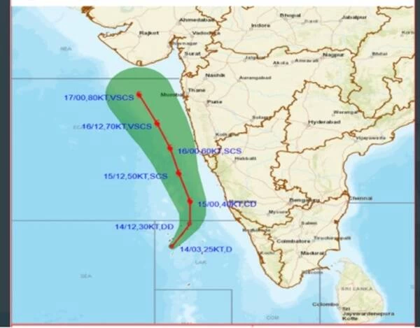
New Delhi: THE MET department has warned against a cyclone, which will form over Southeast Arabian Sea on Saturday, strengthening and intensifying into a ‘very severe’ cyclonic storm (winds with speed of up to 150 to 160 kmph) on May 17.
Prevailing well-marked low pressure system over Lakshadweep developed into a depression on Friday. The India Meteorological Department (IMD) launched a cyclone watch and released the possible track that the cyclone, which is to acquire its name Tauktae, will take in due course. It is headed towards Gujarat and adjoining Pakistan coast.
The rapidly intensifying system shall cause extremely heavy rainfall (more than 204 mm) over Lakshadweep, Kerala, ghats of Tamil Nadu, coastal Karnataka, while Goa and South Konkan regions will receive moderate intensity rain, particularly up to May 17, the IMD has stated.
Officials from the IMD stated that the warm sea surface temperatures over Arabian Sea was aiding rapid intensification of the system while at sea. Wind speeds ranging from 50 to 60 kmph gusting to 70 kmph has been forecast all along the West coast till May 18.
The north Indian Ocean region comprising Arabian Sea and Bay of Bengal are prone to cyclones, mainly in May and November. In a year, this region normally experiences four cyclones, of which three originate in Bay of Bengal.
Data maintained by Regional Specialized Meteorological Centre for Tropical Cyclones over north Indian Ocean suggests that between 1891 and 2021, a cyclone developed over Arabian Sea in May on 33 occasions. Of these, two developed in May in 1932, 1975 and 2018.
In recent years, however, a warming Arabian Sea, too, is witnessing an increase in cyclogenesis. Last June, severe cyclonic storm Nisarga formed here and hit close to Alibaug in Raigad district of Maharashtra, causing widespread damage to the coastal town.
