- India,
- 29-Mar-2020 03:13 PM IST
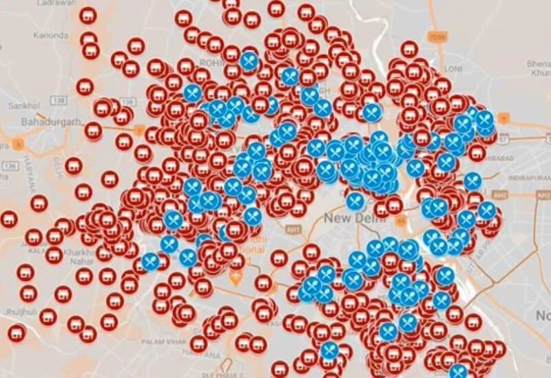
New Delhi: The Aam Aadmi Party (AAP) has organised over 500 relief centres in Delhi to provide food and shelter amid the Covid-19 lockdown. To make things easier, the AAP has launched a customised Google Maps with the locations of all the relief centres.
Relief centres span across the city and people can visit these places for lunch (12-3PM) and dinner (6-9PM) everyday. Needless to say, food will be served free at these relief centres. The map shows locations for shetler homes which are denoted with a fork and spoon symbol in red colour. As for the schools where people can get food, it is denoted with a food and beverage symbol in blue.
Help anyone who is hungry and cannot buy food. Delhi Govt is providing free food to all the needy people.
Share widely and help us in fighting hunger.
One can access the map by following this link on mobile and desktop as well. Here, users can zoom in to get a better look at all the relief centres. Tapping on the location pins will open up the full address of the relief centre. Since the map is built with Google, the navigation will appear on Google Maps. Users can then select the arrow icon for directions to the relief centre.
To get the full list of the relief centres in Delhi simply tap on the #DelhiHungerReliefCentre text below on mobile. The tap on the arrow icon below shelter homes and school to get the full list of all the places. On desktop, it’s much easier as the left tab will have the shelter homes and school list. One would still need to tap on the arrow icon for the drop down list.
Considering people who need these relief centres the most may not have smartphones, people are advised to guide them using this map.
