- India,
- 04-Dec-2023 11:04 PM IST
Michaung Cyclone: Cyclone Michaung, which originated from the Bay of Bengal on December 2, will hit the coast of Andhra Pradesh and Tamil Nadu before 12 am on December 5. According to the Meteorological Department (IMD), winds can blow at a speed of 90 to 110 kilometers per hour (KMPH) during this period. IMD said that the impact of the storm will remain in Odisha, Tamil Nadu, Andhra Pradesh, Telangana and Puducherry. Red alert has been issued in Andhra Pradesh, Tamil Nadu and Puducherry for today and in Telangana for December 5. There is orange alert in Odisha for December 5. SDRF and NDRF teams have been deployed in these states. So far 204 trains and 70 flights have been cancelled.
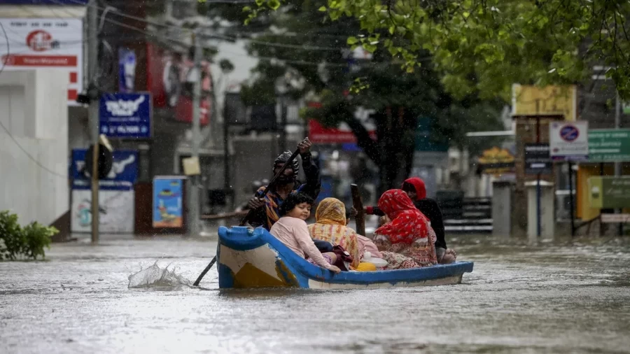
There is a flood like situation due to rain in Chennai, Tamil Nadu. So far 5 people have died. The runway at Chennai International Airport has been closed due to water logging. Due to the storm, the sea level at Mahabalipuram beach in Tamil Nadu has risen by about 5 feet.
According to the Water Supply Minister of Tamil Nadu, this is the first time such rain has occurred in Chennai city in 70-80 years. 12cm rainfall has been recorded in Chennai from Sunday till 8:30 am on Monday. Some areas have received 20 to 22 cm of rain.
Myanmar has given the name Michaung to the storm. It means strength and flexibility. Michong Cyclone is the fourth storm to form in the Bay of Bengal and the sixth in the Indian Ocean in the year 2023.
Monday and Tuesday were declared public holidays in Tamil Nadu except for essential services. 9 teams of NDRF and 14 teams of SDRF are ready here. The runway at Chennai International Airport has been closed from 9:40 am to 11 pm on Monday due to water logging. 70 flights have been canceled here. Flights coming from outside are being diverted to Bengaluru.
Schools and colleges in urban areas remained closed on Monday. Due to heavy rains in some areas, roads were flooded with 3 to 4 feet of water. Some videos from residential areas have surfaced, in which dozens of cars are seen floating in water. Cars were also seen floating on the road. A crocodile was seen roaming on the road in Perungalthur area of Chennai.
Schools closed in Andhra Pradesh on 4 and 5 December
Cyclone Michong will make landfall between Nellore and Machilipatnam coast of Andhra Pradesh on Tuesday. During this period, the wind speed can range from 90-100 km per hour to 110 km per hour. 12 teams of NDRF are deployed for the rescue operation. Schools and colleges will remain closed on 4th and 5th December.
IMD said that at present the storm is over the south-western Bay of Bengal. It is moving towards north-west. By Monday afternoon, it is likely to reach west-central Bay of Bengal via south Andhra Pradesh and north Tamil Nadu coasts.
Orange alert in 5 districts of Odisha. Light rain is occurring in many districts of Odisha. The Meteorological Department has issued a warning of heavy rain till December 6. Orange alert has been issued for Malkangiri, Koraput, Rayagada, Gajapati and Ganjam districts for December 4 and 5. These districts may receive 2.75 to 4.55 inches of rain.
Odisha government has put officers in coastal areas on alert. East Coast Railway has canceled more than 60 trains in view of the possibility of rain and wind. Fishermen have been advised not to venture into the sea.
Alert issued in Puducherry and Telangana also
In view of the storm, the Puducherry government has also issued an alert. Section 144 has been imposed around the marine areas of Puducherry. People have been instructed not to go to coastal areas from 7 pm on 3 December to 6 pm on 5 December. Telangana administration has also issued a red alert regarding the storm.
How will the weather be on December 5th?
According to Skymet, moderate to heavy rain with gusty winds reaching 90 to 100 kmph is possible over Andhra Pradesh during the next 24 hours. Light to moderate rain may occur over parts of East Telangana and Odisha with one or two heavy spells.
Light to moderate rain is possible over Tamil Nadu, Karnataka, West Bengal, parts of Chhattisgarh and Jharkhand. Light rain may occur at 1 or 2 places over Vidarbha, Telangana, Karnataka, Andaman and Nicobar Islands and Kerala.
North India will remain under a blanket of dense fog
There is a possibility of dense fog in the coming days in many cities of North India including Delhi, Punjab, Haryana, Chandigarh. Zero degree mercury was recorded in Pahalgam and Gulmarg areas of Kashmir on Sunday. On the other hand, some areas of Gujarat, Madhya Pradesh, Tamil Nadu, Kerala and Andhra Pradesh received light rain on Sunday.
In October, a storm named Tej arose in the Arabian Sea. Earlier there was a possibility of it coming towards India. Later IMD said that the danger of the cyclonic storm hitting the coastal areas of Gujarat has been averted. This storm has moved towards Oman and Yemen, 1600 km away from Gujarat.
Cyclone Biparjoy, which emerged from the Arabian Sea on June 13, caused a lot of devastation in India. On the evening of June 15, the storm hit Jakhau Port in Kutch district of Gujarat. During this period, winds blew at a speed of 150 km/hour. Due to this, there was heavy rain in the coastal areas of Gujarat and Mumbai. 9 people had died in Gujarat.
Storm Moka struck the Bay of Bengal on May 7. Earlier it was moving towards the Indian coastal area. Later it hit the coast of Myanmar. Due to winds blowing at a speed of about 200 kilometers and heavy rains, roofs of many houses were blown away and mobile towers fell. This storm also affected Bangladesh.
