- India,
- 12-Jan-2026 01:22 PM IST
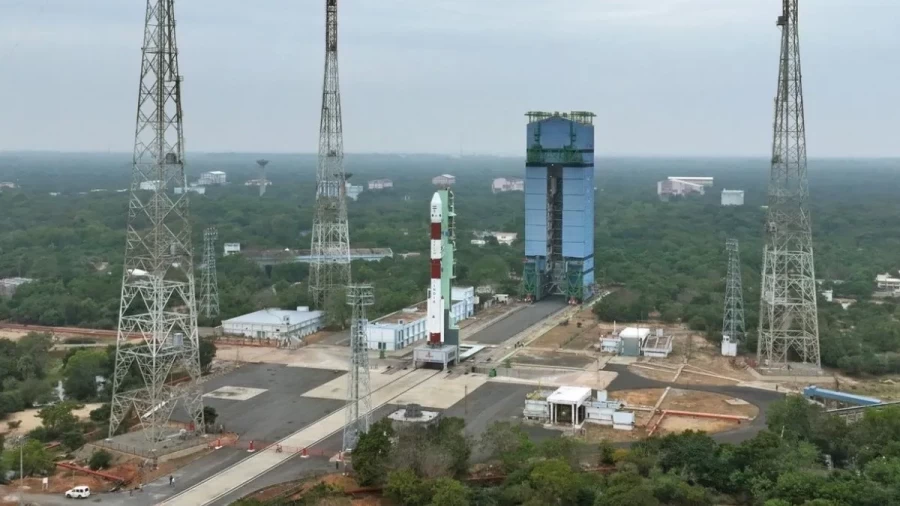
The Indian Space Research Organisation (ISRO) has faced a significant setback at the beginning of 2026, as its first mission of the year, 'PSLV-C62', failed to achieve its objectives, while launched on Monday, 2026, at 10:18 AM from the Satish Dhawan Space Centre in Sriharikota, Andhra Pradesh, the Polar Satellite Launch Vehicle (PSLV) carrying 16 satellites, including the crucial 'Anvesha' spy satellite developed by the Defence Research and Development Organisation (DRDO), encountered a critical malfunction. ISRO Chief Dr. V. Narayanan confirmed the failure, stating that a technical anomaly occurred during the. Rocket's third stage of launch, causing it to deviate from its intended trajectory. This incident marks a serious blow to ISRO, especially given the PSLV's reputation as one of the world's most reliable launch vehicles.
Mission Objectives and Technical Glitch
The primary objective of the PSLV-C62 mission was to precisely deploy EOS-N1 (Anvesha) and 14 other satellites into a Sun-Synchronous Orbit (SSO) at an altitude of 512 kilometers. This specific orbit is crucial for Earth observation satellites as it allows them to pass over any given point. Of the Earth's surface at the same local mean solar time, ensuring consistent lighting conditions for imaging and surveillance. Following the successful deployment of these satellites, the mission plan called for the rocket's fourth stage (PS4 stage) to be re-ignited. This maneuver was designed to reduce the rocket's velocity, enabling a controlled re-entry towards Earth. Subsequently, a KID capsule was intended to separate from the rocket, likely as part of a technology demonstration or future mission test. However, the unforeseen malfunction in the third stage disrupted this intricate sequence of operations,. Leading to the rocket's deviation and the mission's ultimate failure to reach its intended destination. This failure not only resulted in the loss of valuable satellites but also raises questions about the immediate future of ISRO's ambitious space programs.
Anvesha: India's Advanced Intelligence Satellite
The 'Anvesha' satellite, a key payload on the ill-fated mission, represented a highly significant and strategic asset developed by the Defence Research and Development Organisation (DRDO). It was designed as an advanced imaging spy satellite, with its core purpose being precise surveillance and mapping. Anvesha's most remarkable capability lay in its ability to capture clear images of enemies hidden within dense bushes, forests, or even fortified bunkers, despite being hundreds of kilometers above the Earth's surface. This capability was poised to set it apart from conventional surveillance satellites, offering a potential game-changer for India's defense capabilities. Its high-resolution imaging and penetration capabilities would have made it an invaluable tool. For gathering military intelligence, providing a critical advantage in both tactical and strategic operations.
Hyperspectral Remote Sensing (HRS) Technology
The extraordinary capabilities of the Anvesha satellite were rooted in its sophisticated 'Hyperspectral Remote Sensing' (HRS) technology. This technology is far more advanced than traditional imaging, as it detects a much broader spectrum of light, while while conventional cameras typically capture only a few primary colors, HRS can discern hundreds of subtle shades and spectral bands. This enhanced capability allows the satellite to identify the 'fingerprint' of objects based on their unique spectral signatures. For instance, by detecting these minute color variations, the satellite could determine the actual composition of an object in an image, while it functions much like a sophisticated scanner, capable of identifying different types of soil, plant species, human activities, or any object by its distinct spectral glow or reflection. Through this technology, Anvesha was engineered to analyze the detailed chemical and physical composition of any area, providing an unprecedented level of information.
Anvesha's Benefits for the Defense Sector
The HRS technology embedded in the Anvesha satellite made it an exceptionally powerful tool for the defense sector, offering numerous potential applications that could provide significant strategic advantages to military forces:
Terrain Analysis:
Through HRS technology, the type of soil in a particular area (e. g, while , desert or sticky soil) could be accurately detected. This information would be crucial for military planning, helping to determine whether tanks or other heavy vehicles could traverse specific terrains, thereby aiding in operational logistics and route selection.
3D Imaging and Simulation:
During wartime, the data and images acquired through HRS could be utilized to create detailed 3D simulations of the battlefield, while these simulations would assist military forces in selecting optimal routes, understanding enemy formations, and continuously monitoring enemy movements in border areas. This would provide a superior real-time understanding of the operational environment.
Detection of Hidden Objects:
In densely forested areas, it's relatively easy to conceal personnel or equipment. Anvesha's HRS technology had the capability to detect enemy personnel hidden within bushes or even weapons submerged beneath river water. This ability would play a vital role in uncovering clandestine enemy activities and movements.
Environmental Monitoring:
Beyond defense, the satellite could also be employed for civilian applications such as monitoring forests, overseeing mining operations, and measuring greenhouse gas emissions. This versatility would have made Anvesha a multi-utility satellite with broad applications.
PSLV's Reliability and Past Failures
The PSLV (Polar Satellite Launch Vehicle) is widely regarded as the most reliable rocket in the Indian Space Research Organisation's fleet. It has successfully completed 63 flights to date and has been instrumental in launching many of India's major and historic missions, including Chandrayaan-1, Mangalyaan (MOM), Aditya-L1, and Astrosat. In 2017, the PSLV also set a world record by launching 104 satellites in a single mission, firmly establishing its capabilities on a global scale, while however, recent failures are casting a shadow over this otherwise dependable rocket. Just eight months prior to this latest incident, on May 18, 2025, ISRO's PSLV-C61 mission also failed due to a technical glitch in its third stage, while that mission was intended to place the EOS-09 Earth Observation Satellite into a 524 km Sun-Synchronous Polar Orbit. Two consecutive failures, particularly involving the rocket's third stage, have become a subject of intense analysis and corrective action for ISRO's engineers.
Global Landscape of Hyperspectral Satellites
India isn't alone in its pursuit of hyperspectral imaging satellite technology. Several other leading space-faring nations worldwide have also developed these advanced capabilities. Apart from India, six other countries—the USA, China, Germany, Japan, Italy, and Pakistan—have successfully launched hyperspectral satellites. India had previously launched its first hyperspectral imaging satellite, named HySIS, on November 29, 2018, while this satellite weighed 380 kilograms and was capable of detecting light across 55 spectral bands. Anvesha was designed as an upgraded version of HySIS, boasting even higher hyperspectral capabilities, which would have enabled it to provide more detailed and accurate data. Despite this recent setback, India's progress in hyperspectral technology is expected to continue, as it remains crucial for the nation's defense and environmental monitoring capabilities, while iSRO must now thoroughly investigate the causes of these failures to ensure the success of future missions and to advance India's ambitious space aspirations.
