- India,
- 10-Jun-2022 08:59 PM IST
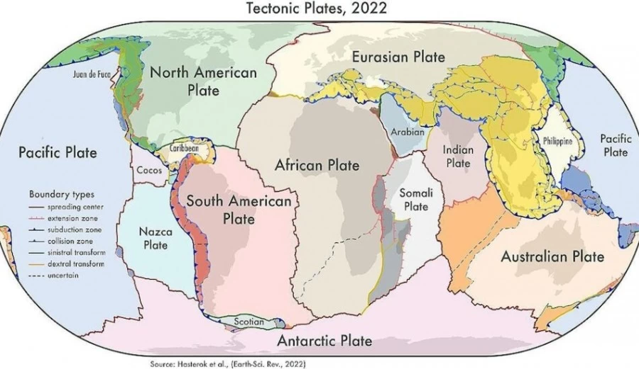
A new map of the Earth's global geological regions, ie land areas and tectonic plates, has been made. Due to this, it will help in studying the changes taking place in the upper layer of the Earth. Also, this map will be beneficial for those who study natural disasters like earthquakes and volcanic eruptions. This study has been done by Dr. Lecturer of the Department of Earth Sciences at the University of Adelaide, Australia. Derrick Haystrock and his teammates.
Doctor. Derrick explained that we compared the formation of the boundary zones of the plates and the structure of the old continental crust. studied them. The continents are connected like jigsaws. Each time they keep on connecting and breaking like a puzzle. Let's make a new picture and a new map. Our study will help us learn how to combine each piece to create a newer picture than the old one. Two new things have come to the fore in this map. The first is that the microplate between the Indian plate and the Australian plate has been included in the map. Second is that India is moving towards Europe.
Doctor. Derrick said that the boundary zones of tectonic plates cover 16 percent of the Earth's crust. While 27 percent of the continent. We have created three new geological models from the new study. The first is the plate model, the second is the province model and the third is the orogeny model. Orogeny model means the process of formation of mountains.
There are 26 orogenes on Earth. That is, they are formed by the movement of the crust or the collision of plates. These 26 orogenes of mountains match the current architecture of the earth. Many of these plates have helped in the formation of supercontinents. Doctor. Derrick told that his task is to study the formation of tectonic plates. As well as understanding their updated boundaries, so that natural disasters like earthquakes and volcanoes can be assessed.
Doctor. Derrick said that the tectonic plate map that was currently in place was based on topographic models and global seismic activity. It was not updated since 2003. Several microplates have also been included in our new map. Such as the Macquare Microplate in the south of Tasmania and the Capricorn Microplate that separates the India and the Australian Plate.
The biggest change has been seen in the plates of western-North America. Its boundary forms with the Pacific Plates, which is joined by the San Andreas and Queen Charlotte Faults. But now 1500 km wide inner line i.e. valley has been seen between these faults. It is increasing the distance between these two plates.
After this the biggest change has come in Central Asia. The new model suggests that a deformation zone is being seen in the north of India. Because the Indian plate is constantly moving towards the Eurasian plate. Scientists have not told about what effect this will have on the geographical and geological situation of India. But it is certain that in future India will not have its positive effect.
This study has recently been published in the journal Earth-Science Reviews. Doctor. Derrick said that our map tells the full story of 90 percent of earthquakes and 80 percent of volcanic eruptions on Earth in the last two million years. Whereas the current models give details of only 65 percent of the earthquakes. With the help of this map people can calculate natural disasters.
