- NEW ZEALAND,
- 11-May-2021 06:49 AM IST
The hidden eighth continent of the earth has ripped the chest of our earth. It has created another major crack ie subduction zone. This subduction zone is formed under the sea near New Zealand. That is, another Technonic plate has formed below the sea surface of New Zealand. If there is a movement in this tectonic plate, terrible earthquakes and tsunamis can occur around New Zealand. This subduction zone is formed below the Tasman Sea. This area is located south of New Zealand.
This subduction zone is formed on the Puysegur Trench located south of New Zealand. Due to the formation of this subduction zone, the Australian tectonic plate has moved here and has gone under the Pacific Technotonic Plate. If there is a slight movement here, then like the tsunami that occurred in the year 2004, there can be catastrophe. An earthquake of magnitude 7.2 or above may occur. Scientists are claiming this because this subduction zone is still young.
This eighth continent of Earth is on the southeast from Australia to New Zealand. Recently its map was made. Which shows that it is spread over 5 million square kilometers. That is, it is about 17 lakh square kilometers bigger than the area of India. The area of India is 32.87 million square kilometers. The name of this eighth continent is Zealandia. Scientists said that it sank into the sea around 2.30 million years ago.
Zealandia lies on the border of the Australian tectonic plate and the Pacific tectonic plate. Researcher Brandon Schuck of Austin-based The University of Texas said that by studying such subduction zones, we would be able to gather more information about the cracks being formed on the chest of the Earth. At the same time, we will also know what level of earthquake can occur due to the formation of such subduction zones. However, it is not yet known how this crack formed? Where did it begin?
Zeelandia was broken by 7.90 million years ago from the supercontinent Gondwanaland. This continent was first discovered about four years ago. Since then, scientists are constantly doing research on this. Last year, scientists in New Zealand prepared its tectonic and bathymetric map. So that the seismic activities and marine information related to it can be known. GNL Science geologist Nick Mortheimer said that these maps tell us about the world. These are a major scientific achievement.
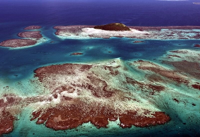
Nick said that the concept of the eighth continent came in 1995. But it took time until 2017 to find it and then it was recognized as the lost eighth continent. Zeelandia is present inside the Pacific Ocean at a depth of 3800 feet. The new map has revealed that Zealandia has very low-lying land. Somewhere there are very high mountains and somewhere deep valleys.
The whole of Zealandia is under the sea, but a rock (in the photo) named Balls Pyramid near Lord Howe Island is out of the sea. It is from this place that there is another continent under the sea. Brandon says that the formation, deterioration and dismantling of the subduction zone is a mystery. When a marine layer goes under or falls above a continent layer, then shapes like high-rise hills are formed on the surface. The surface breaks. It worsens. This poses a risk of earthquake and tsunami.
The history of the new subduction zone built under the Puysegur Trench is brand new. Therefore, scientists will get many new information from its study. However, studying this place is not so easy. It is fatal 20 feet high waves arise here. The wind moves at a speed of 48 kilometers per hour. This happens on normal days. If you know under the Tassman Sea, then the speed of the waves there is more rapid.
Brandon Schuck said that we had gone to study the area in 2018, riding in the research vessel Marcus Langseth, which was very dangerous. A quarter of the day was spent on an island hiding behind the stones because the wind and waves were so strong here that they could pick up your body and throw it somewhere. When she was a little quiet, we used to go back to the sea to study.
Brandon told that our Vessel used to walk along the islands all the time in the sea. The waves and wind were so strong that the Vessel was always tilted 20 degrees to one side. In spite of inclement weather, we installed seismometers inside the marine to check seismic movements on the ocean surface. The sound wave is released from this device which produces 3D maps based on different geographical shapes present inside the ocean.
On 22 April 2021, this study of Brandon Schuck and his team is published in the journal Tectonics. Brandon says that the formation of this subduction zone plate has started 45 million, or 450 million years ago. It is formed between the Australian and Pacific plates. The formation of this crack caused the two plates to be slightly distended. Due to which the hot lava in the center of the earth started coming up. Because of that new stones were made. Gradually, with the addition of these stones, a whole new plate of puri was formed.
Such geological movements have not just happened under New Zealand, the eighth continent near New Zealand. Brandon reports that the slightly older plate is formed in the south of Alaska and north of Vancouver. It is called the Queen Charlotte Fault. Sai
