- India,
- 02-Nov-2025 09:17 AM IST
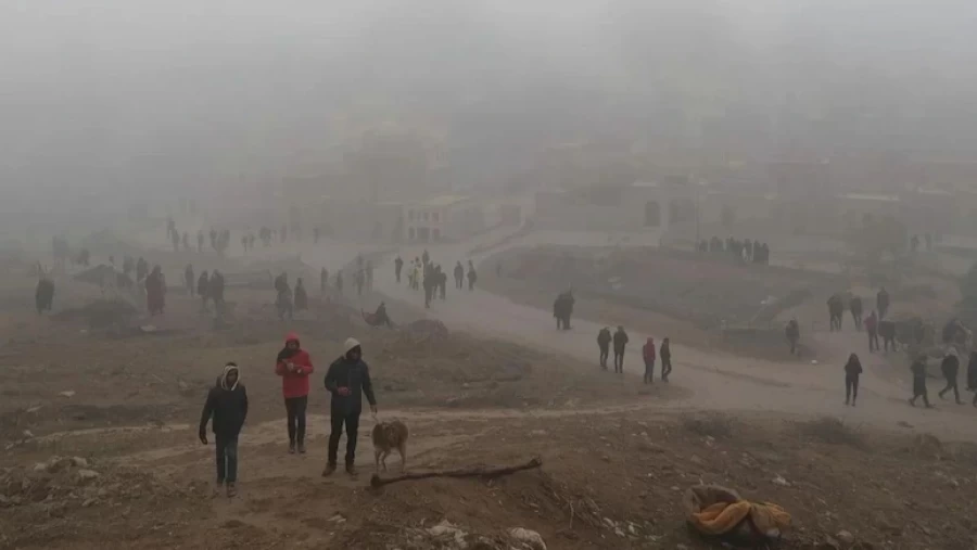
Rajasthan has been experiencing a continuous spell of unseasonal rainfall even in late October, Notably disrupting the typical weather patterns for the month, while usually, by October, the monsoon recedes, and the state transitions into dry, clear weather. However, this year, the situation has been quite the opposite, while the persistent rainfall has not only affected agricultural activities but has also had an impact on daily life. This unusual meteorological activity led to dense fog in several districts during the morning hours, severely limiting visibility, while areas such as Kota, Nagaur, Alwar, Sikar, and Bundi reported visibility as low as 15 meters, which Notably slowed down vehicular movement and daily routines. Roads filled with slow-moving vehicles and cities enveloped in mist presented an unexpected sight, highly unusual for a month like October. This situation has posed challenges for both commuters and local residents, especially during the morning rush hours.
Record-Breaking 412% Above Normal Rainfall Recorded
According to the latest data released by the India Meteorological Department (IMD), Rajasthan recorded an astonishing 412 percent more rainfall than its normal average for October, marking a record-breaking figure. The typical rainfall for October is a mere 10. 8 percent, clearly highlighting the extraordinary nature of this year's precipitation. This significant deviation indicates that Rajasthan has faced unusually heavy rainfall, surpassing records from several decades past. The primary reason attributed to this excessive rainfall is the formation of various weather systems in the Arabian Sea, which have directly and profoundly influenced the state's climate. These meteorological systems pushed moisture into the state, leading to continuous and heavy downpours. This exceptional rainfall has not only replenished water bodies but has also. Created waterlogging situations in some low-lying areas, requiring local administration to remain vigilant.
November Weather Alert Issued for Rain and Temperature Drop
The Meteorological Department has issued a weather alert for November, forecasting continued rain and a drop in temperatures, suggesting that this period of unseasonal weather might persist for some time. As per the department, a new weather system, identified as a Western Disturbance, is expected to affect the state, while this system is predicted to bring rain to several areas of Rajasthan and cause a further drop in temperatures. Western Disturbances are extra-tropical storms originating in the Mediterranean region that bring sudden winter rain to the northwestern parts of the Indian subcontinent. Their activation is set to bring noticeable changes to Rajasthan's weather, leading to a significant reduction in both day and night temperatures. This could be a concern for farmers, as it might adversely affect their crops, while the general public will need to adjust their routines and attire according to the changing weather, while
Arabian Sea Depression: Forecast for November 1st and 2nd
The Jaipur Meteorological Centre reported that the depression formed in the Arabian Sea has weakened and transformed into a 'Well Marked Low Pressure Area' (WML). This meteorological system, although weakened, will still exert its influence over certain parts of the state. Under its impact, light rainfall is anticipated at isolated places in the Udaipur and Kota divisions on November 1st and 2nd. This rainfall will be localized and light in nature, potentially offering some relief in these areas, while however, most other parts of the state are expected to remain dry during this period, meaning that the majority of districts will experience clear skies and normal temperatures. This indicates that the impact of rain will be limited to specific regions during the first two days of November, with expectations of a more widespread weather change thereafter, while
Lunkaransar Recorded as the Coldest City, Barmer with Highest Max Temperature
According to the daily data report from the Meteorological Department, Saturday witnessed predominantly dry weather across the state, with sunny conditions prevailing during the day. Regarding temperatures, Barmer recorded the highest maximum temperature at 35, while 9 degrees Celsius, indicating warm daytime conditions, especially in areas experiencing dry winds. Conversely, Lunkaransar emerged as the coldest city in the state, with a minimum temperature of 15. 2 degrees Celsius. This temperature suggests cool nights and mornings, prompting residents to opt for light warm clothing. Observations also indicated that the average humidity in most parts of the state ranged between 40 to 80 percent, signifying the presence of moisture in the air. This humidity could be responsible for the morning fog and evening dew observed in various regions.
Analysis of Minimum Temperatures Across Key Districts of Rajasthan
On Saturday, the minimum temperatures recorded in various key districts of Rajasthan were as follows, illustrating the temperature patterns across the state: Ajmer at 16, while 5 degrees, Bhilwara at 19. 4 degrees, Alwar at 18, while 8 degrees, Jaipur at 21. 0 degrees, Pilani at 18. 8 degrees, Sikar at 15, while 2 degrees, Kota at 21. 9 degrees, Chittorgarh at 19. 6 degrees, Barmer at 20. 3 degrees, Jaisalmer at 18. 7 degrees, Jodhpur at 18. 5 degrees, Bikaner at 19. 8 degrees, Churu at 17. 4 degrees, and Sri Ganganagar at 18, while 2 degrees Celsius. Also, Nagaur recorded 19. 2 degrees, Jalore 17. 1 degrees, Sirohi 16. 5 degrees, Dausa 19. 6 degrees, and Jhunjhunu 19, while 5 degrees Celsius. These figures indicate that most parts of the state experienced relatively cool. Nights, but some northern and western districts felt a more pronounced chill. This distribution of temperatures also reflects the geographical diversity of the state.
Impact of New Western Disturbance on November 3rd and 4th
A new Western Disturbance is. Expected to become active from November 3rd, bringing another significant change to Rajasthan's weather. This Western Disturbance, known for influencing the weather of North India, will bring rain and thunderstorms to several parts of the state. Under the influence of this new weather system, light to moderate rainfall, accompanied by thunder, is likely in some parts of the Jodhpur, Udaipur, Ajmer, Jaipur, Bharatpur, and Kota divisions on November 3rd and 4th. This rainfall could be crucial for crops, but excessive amounts might also cause damage, while during this period, the Bikaner division is also expected to experience partly cloudy skies, leading to increased humidity and cooler conditions. This Western Disturbance is poised to affect a large portion of the state, advising farmers and the general public to remain vigilant for the upcoming days.
Weather Changes and Temperature Drop Post-November 5th
From November 5th onwards, most parts of the state are highly likely to experience dry weather for the subsequent week, bringing an end to the rainy spell and leading to clearer skies. During this period, the influence of northerly winds will intensify, bringing cold air from the Himalayan regions. Due to these cold winds, a drop in minimum temperatures by two to four degrees Celsius is anticipated. This change will lead to an increase in cold, making mornings and evenings Notably chillier, prompting people to require warmer clothing. This dry and colder weather typically commences from mid-November, but this year, following the unusual October rains, this shift is occurring slightly later than usual. This period will signal the onset of winter, with pleasant days and cold nights.
