
- India,
- 05-Sep-2026 12:02 PM IST



The United Nations General Assembly has officially approved a landmark proposal to change the representation of the world map, ensuring that the African continent is depicted in its true and accurate size. This significant move aims to rectify centuries of geographical distortion that have historically made Africa appear much smaller than it actually is in comparison to northern landmasses like Europe and North America. The proposal, which was formally introduced by Togo, received overwhelming support from the international community, marking a pivotal moment in how the world perceives global geography.
The Global Vote and Diplomatic Stance
The resolution saw a decisive victory in the UN General Assembly, with 164 countries voting in favor of the change. The African Union and its member states were the primary drivers behind this initiative, advocating for a map that reflects the physical reality of the planet. However, the decision wasn't unanimous. The United States stood as the sole dissenter, casting the only vote against the proposal, while Also, 6 countries chose to abstain from the voting process. While the UN's decision isn't legally binding and doesn't impose a legal ban on existing maps, it serves as a powerful recommendation for schools, international institutions, and digital platforms to adopt the more accurate representation under the Correct the Map campaign.
The 500 Year Old Problem with the Mercator Map
The map that has been the standard for centuries is known as the Mercator projection. It was created in 1569 by the Flemish cartographer Gerardus Mercator. At the time of its creation, the primary purpose of the map was to assist European sailors in navigating the oceans. To make navigation easier, Mercator had to represent the spherical Earth on a flat, two dimensional surface. While this was revolutionary for maritime travel, it introduced significant distortions in the size of landmasses, while in the Mercator projection, regions near the equator appear much smaller than they're, while regions closer to the poles, such as Europe, North America, and Greenland, appear much larger.
Africa vs Greenland: A Stark Contrast
One of the most cited examples of this distortion is the comparison between Africa and Greenland. On a standard Mercator map, Africa and Greenland appear to be roughly the same size. In reality, Africa is approximately 14 times larger than Greenland. Critics of the old map argue that such inaccuracies have long term psychological and political effects, as they diminish the perceived importance and developmental needs of Africa and other equatorial regions. The new initiative seeks to correct this visual bias by promoting maps that show the true scale of the continents.
The Equal Earth Projection: A Modern Solution
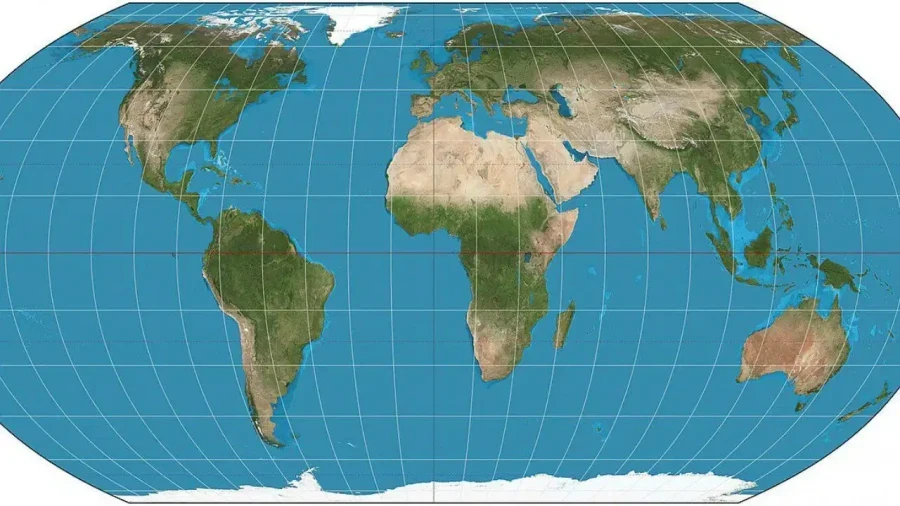
To address these historical inaccuracies, cartographers developed the Equal Earth projection in 2018. This projection is designed to show the relative areas of the continents as accurately as possible. In February, all 54 member states of the African Union adopted this projection, noting that it provides a much better representation of Africa's massive land area. Supporters of the #CorrectTheMap campaign highlight that Africa is so large that it can encompass the landmasses of the United States, China, India, Japan, Mexico, and a large portion of Europe combined, with land still left over.
Political and Social Perspectives
The debate over the map has sparked various reactions from global leaders and experts. Robert Dussey, the Foreign Minister of Togo, emphasized the importance of this change, stating that a just world begins with a just map. He argued that maps deeply influence how people think and how they understand the position of different continents in the world. Jean Noel Barrot, the Foreign Minister of France, also supported the change, noting that while changing a map doesn't change the world itself, correcting a false image is a step toward the truth.
On the other hand, the United States representative to the UN, Yarina Ferencevych, opposed the resolution. She stated that the UN should focus on real issues such as international peace, prosperity, and good relations between countries, rather than focusing on 16th century maps. However, experts like Lerato Mogoatlhe from Africa No Filter argue that misrepresenting Africa's size isn't just a cartographic error but a question of perception, while kenyan geographer Kioko Muendo added that maps do more than just show the way; they play a crucial role in shaping the political, economic, and social image of a region.